

Ituri Province
Ituri is the core geography for this Congo Ebola event. WHO reporting names health zones including Mongbwalu, Rwampara and Bunia as important outbreak areas.
This DRC Ebola outbreak 2026 briefing tracks Congo outbreak context, source dates, affected provinces, and links to the live Ebola Map 2026. It keeps suspected cases, confirmed cases and deaths separate.
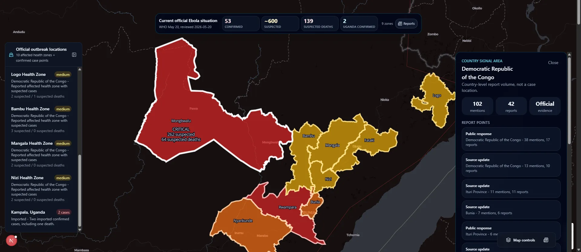
DRC Ebola outbreak 2026 map context
Source-linked map preview. Use official sources for policy, travel and medical decisions.
Source date
May 31, 2026
Last reviewed
June 1, 2026
DRC confirmed
282
DRC suspected
220
The DRC Ebola outbreak 2026 figures above use this site's current source snapshot. Counts may differ across WHO, ECDC, CDC and ministry updates because confirmed, suspected and death categories move on different reporting timelines.
Current situation
The DRC Ebola outbreak 2026 is an active Ebola disease event in the Democratic Republic of the Congo, linked by official sources to Bundibugyo virus disease. WHO, ECDC and CDC describe the outbreak as occurring with linked Uganda case context, and WHO has classified the event as a Public Health Emergency of International Concern.
For readers, the main job is careful interpretation. The DRC Ebola outbreak 2026 includes confirmed cases, suspected cases, deaths, contact tracing and response activity. Those categories should not be merged into one simple number. This page uses source dates so a reader can see when each outbreak snapshot was reviewed.
Ituri is the core geography for this Congo Ebola event. WHO reporting names health zones including Mongbwalu, Rwampara and Bunia as important outbreak areas.
North Kivu appears in official updates as part of the expanded DRC context. Read it as provincial outbreak context, not a precise household-level map point.
CDC's May 31 update continued to report confirmed DRC spread across Ituri, North Kivu and South Kivu after case reclassification. Counts and classifications can change as public health teams investigate.
Map reading guide
This briefing gives the DRC context. The map gives the geographic layer. Reading them together helps avoid confusing report volume with confirmed local transmission.
Use this page to understand the DRC provincial picture first. Ituri is the main geography, while North Kivu and South Kivu are read through the source dates attached to official updates.
Use the Ebola Map 2026 to inspect affected health-zone polygons, case points and country-level report signals. A polygon is an area-level public health record, not a street address.
If a number or location matters, compare the source date on this page with the source link on the map. Outbreak categories can change after laboratory review and field investigation.
Timeline
This timeline summarizes public-source milestones. It is a reading guide, not a replacement for WHO, ECDC, CDC or DRC Ministry of Health updates.
A hospital cluster in northeastern Congo became the first public signal behind the current DRC outbreak.
DRC authorities declared Ebola disease after laboratory confirmation of Bundibugyo virus disease.
WHO determined that the DRC and linked Uganda event constituted a PHEIC, not a pandemic emergency.
WHO, CDC and ECDC updates described activity across Ituri, North Kivu and South Kivu, with counts changing as investigations continue.
Boundaries
A useful public health page should be clear about its limits. This page is designed for source review and geographic orientation, not private case tracking or medical decision-making.
How to read the data
Confirmed DRC cases are laboratory-supported records in official reporting.
Suspected cases are important for response, but they are not the same as confirmed Congo Ebola cases.
Border screening, contact tracing and preparedness records can appear in coverage without proving new local transmission.
Latest reviewed official case-count snapshot and U.S. public health context.
Same-day European public health update, useful for cross-checking.
WHO outbreak hub for the Democratic Republic of the Congo, 2026.
Detailed WHO outbreak notice with DRC health-zone context.
Emergency Committee statement and temporary recommendations.
This DRC briefing summarizes official DRC, WHO, ECDC and CDC updates and links readers to the live map for source-linked locations.
Cette page résume l'épidémie d'Ebola 2026 en RDC avec des sources OMS/CDC, les zones touchées et un lien vers la carte actualisée.
Ukurasa huu unaeleza mlipuko wa Ebola DRC 2026 kwa kutumia vyanzo vya WHO na CDC, maeneo yaliyoathiriwa na kiungo cha ramani.
Esta página resume el brote de ébola en la RDC en 2026 con fuentes de la OMS y los CDC, zonas afectadas y acceso al mapa.
Yes. WHO, ECDC and CDC describe an active DRC Ebola outbreak 2026 caused by Bundibugyo virus disease, with linked Uganda case context.
The outbreak is centered in northeastern DRC, especially Ituri Province, with official updates also naming North Kivu and South Kivu.
No. The current DRC Ebola outbreak 2026 is linked to Bundibugyo virus disease. Ebola vaccines and treatments can differ by virus species, so official guidance matters.
Keep confirmed cases, suspected cases and deaths separate. WHO, ECDC and CDC note that the outbreak is evolving, so numbers should be read with source dates.
No. The map uses source-linked points and affected health-zone areas. It does not identify patient homes or exact exposure locations unless a source clearly supports that level of detail.
This DRC Ebola outbreak 2026 page is for public awareness and source review. It is not a medical diagnosis tool, travel clearance system, official case registry or exposure assessment. For symptoms, exposure, travel or emergency decisions, use qualified medical care and official public health authorities.